Trail Other activity Clos du Doubs - St. Ursanne - Le Noirmont - Photo
 bffcuc
bffcuc

User

© OpenStreetMap contributors
Length
Length
37 km
Max alt
Max alt
1097 m
Uphill gradient
Uphill gradient
1319 m
Km-Effort
Km-Effort  
53 km
Min alt
Min alt
433 m
Downhill gradient
Downhill gradient
840 m
Boucle
Boucle
No
Creation date :
2014-12-11 00:00:00.0
Updated on :
2014-12-11 00:00:00.0

(0 Reviews)

Other activity
Other activity
--
Difficulty : Unknown

Scan this QR Code to open this trail in the SityTrail application

FREE GPS app for hiking

Logo SityTrail SityTrail

IGN / Geographical institutes

Download SityTrail from the App Store Download SityTrail from Google Play

Logo SityTrail SityTrail World

The world is yours!

Download SityTrail from the App Store Download SityTrail from Google Play Download SityTrail on Huawei AppGallery

About

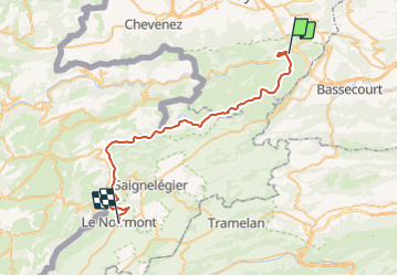
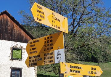
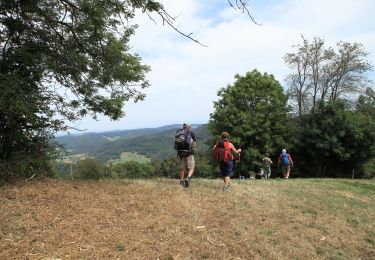
Trail Other activity of 37 km to be discovered at Jura, District de Porrentruy, Clos du Doubs. This trail is proposed by bffcuc.

Description

Anstrengende aber grossartige Tour duch den Nationalpark.

Von Buffalora aus steigt man an den alten Eisenerzminen vorbei zum Nationalpark auf. Danach verläft die Route auf gut 2''300 Metern Höhe richtung Munt la Schera. Gämsen und Murmeltiere können beobachtet werden. Danach steigt man zum Plateau des Munt la Schera hoch, von wo man eine grossartige Aussicht hat. Danach gehts runter auf die Alp la Schera und weiter Richtung Spölschlucht. Kurz vor der Staumauer zweigt man rechts ab und überquert die Spöl. Dann folgt man hoch über dem FLuss dem Verlauf der Schlucht bis man auf den Fussweg der vom Munter herunterommt trifft. Hier überquert man die Spöl erneut, traversiert dann die Ofenpasstrasse und wandert durch einen schönen Bergwald hoch zur Alp Grumells. Von her hat man einen wunderbaren Ausblick ins Fuorn-Tal. Danach geht es runter nach Il Fuorn. Hier gibt es ein Hotel, es ist die einzige Verpflegungsmöglichkeit während der ganzen Wanderung. Dnach folgt man dem Fuorntal hoch in zurück nach Buffalora. Dieser Teil der Wanderung ist nicht mehr sonderlich attraktiv. Wer will kann auch das Postauto nehmen.  

Elevation profile

Positioning

Country:
Switzerland
Region :
Jura
Department/Province :
District de Porrentruy
Municipality :
Clos du Doubs
Location:
Unknown
Start:(UTM)
361638 ; 5247617 (32T) N.

Trails nearby

Trail On foot Haute-Sorne - Berlincourt - fixme - Photo
On foot
PRO

On foot

Easy
Haute-Sorne, Jura, District de Delémont, Switzerland
4 km | 8.9 km-effort
2h 1min
No
Trail On foot Haute-Sorne - Berlincourt - La Racine - Photo
On foot
PRO

On foot

Easy
Haute-Sorne, Jura, District de Delémont, Switzerland
6 km | 12.2 km-effort
2h 46min
No
Trail On foot Haute-Sorne - Glovelier-St.Ursanne - Photo
On foot
PRO

On foot

Easy
Haute-Sorne, Jura, District de Delémont, Switzerland
4.1 km | 7.6 km-effort
1h 44min
No
Trail On foot Saint-Brais - Tariche - Pont de Ravines - Photo
On foot
PRO

On foot

Easy
Saint-Brais, Jura, District des Franches-Montagnes, Switzerland
4.1 km | 5 km-effort
1h 7min
No
Trail On foot Saint-Brais - Tariche - Le Poye - Photo
On foot
PRO

On foot

Easy
Saint-Brais, Jura, District des Franches-Montagnes, Switzerland
3.4 km | 4.8 km-effort
1h 5min
No
Trail On foot Clos du Doubs - Col de la Croix - Seleute - Photo
On foot
PRO

On foot

Easy
Clos du Doubs, Jura, District de Porrentruy, Switzerland
4.3 km | 6.3 km-effort
1h 26min
No
Trail On foot La Baroche - Pleujuse - fixme - Photo
On foot
PRO

On foot

Easy
La Baroche, Jura, District de Porrentruy, Switzerland
3.1 km | 5.6 km-effort
1h 16min
No
Trail Cycle Clos du Doubs - St.Ursanne - Basel (Jura Suisse) - Photo
Cycle
karawatsj

Cycle

Difficult
Clos du Doubs, Jura, District de Porrentruy, Switzerland
68 km | 88 km-effort
5h 45min
No
Trail Walking La Baroche - Les Rangiers - Photo
Walking
tiene

Walking

Medium
La Baroche, Jura, District de Porrentruy, Switzerland
19.9 km | 30 km-effort
6h 28min
Yes


Close
My subscriptions